Jack Wasey
King's College

Cambridge University
Geological Mapping Expedition, Eastern Transvaal
South Africa, 1998
Contents
Abstract . . . . . . 3
Introduction . . . . . 3
Structure . . . . . 4
History of the Kaapvaal Craton . . . 10
Environment of Deposition . . . 17
Lithology Descriptions . . . . 19
Conclusion and Synthesis . . . . 23
Bibliography . . . . . 24
Appendix . . . . . 26
Abstract
This report describes in detail the geology of seven square kilometres of early Proterozoic sediment in the Eastern Transvaal, South Africa. In addition, the regional geology will be discussed at length, due to a premature end to my data collection owing to injury. The area of study lies ~30km to the north-east of the Bushveld Intrusion on the ancient Kaapvaal craton, and in this report the intrusion's various influences on the surrounding rock are discussed. The structure around the Bushveld is probably influenced by subsidence after intrusion. The sedimentary sequence which I studied originally lay under the intrusion. Faulting is absent, but the area is deformed by folds on wavelengths varying from 100m to 1km. The dominant rock type is dolomite, occasionally inter-bedded with shale. Within the dolomite were algal structures from sub-centimetre scale to one or two metres. Laminations and intercalated beds of silicified dolomite, or pure chert within the dolomite were invaluable in revealing these algal structures and also bedding, as the pure dolomite was virtually featureless in outcrop. Some mineralisation was found in the dolomite, mainly of iron and manganese oxides, and galena.Introduction
The aim of the project was to map an area of at least twelve square kilometres on a scale of 1:10,000 and to produce a comprehensive report. I was one of six who organised an expedition to South Africa. We contacted two South African geologists: Mike Watkeys and Ron Uken who suggested the area of study. The area lies in the Lekgalameetse Nature Reserve in the Eastern Transvaal, now Northern Province, 30 kilometres northeast of the Bushveld Complex. The area was previously unmapped, although studies have been done on the Transvaal Supergroup, and the region was surveyed at a scale of 1:125,000 in 1959. I was mapping the Malmani Sub-Group which lies in the Chuniespoort Group of the Transvaal Supergroup. Exposure was quite good in general, but not often so in crucial places. We arrived in the field area in the beginning of August, and began mapping on the 7th August. My part of the area lay in the northwestern half of the square between 30° 09' and 30° 12' longitude, and 24° 09' and 24° 12' latitude. Unfortunately, I tore ligaments in my right ankle on the 23rd after only 13 days of mapping. This meant I did not have the opportunity to do any traverses to produce detailed data for stratigraphic logs, or cross-sections, nor to consolidate the information which I had gleaned during what turned out to be the whole of my time mapping.
 Structure
 Folding
The structure of my area is dominated by a broad upright anticline with a fold axis trending to 260°
, plunging at 16°
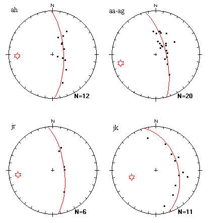
. Most of the individual folds which were mapped within my area fitted well with the average trend and plunge given by all my data. Fig. 1 shows the distribution of all my bedding plane data on an southern hemisphere equal area projection stereo-plot.
Fig. 3 shows four examples of bedding plane data collected from individual folds.
Folding
The structure of my area is dominated by a broad upright anticline with a fold axis trending to 260°
, plunging at 16°
. Most of the individual folds which were mapped within my area fitted well with the average trend and plunge given by all my data. Fig. 1 shows the distribution of all my bedding plane data on an southern hemisphere equal area projection stereo-plot.
Fig. 3 shows four examples of bedding plane data collected from individual folds.

 To the south, major parasitic folds of wavelengths of ~100m are themselves parasitised by folds of wavelength of the order of 0.1 metres to 10 metres; see Fig 5. To the west, all the parasitic folds fade out, and to the north are entirely absent. It is on a limb of one of these parasitic folds in the south that the beds become overturned. This was not observed in the field, but follows from my interpretation of the field data in the cross-section.
 Shale beds influencing topology
A notable feature of the area is that the friable shale beds define some major features of the topology. Both the north and south slopes of the broad 1496m peak are delineated by the Sh2 shale unit, as is the E-W valley along line 745. This is true both in the east and west of my area, as the two cross-sections reveal.
On the map, patches of higher and lower strata appear on these hillsides when erosion has cut deeper, or shallower. These hillsides were poorly exposed, so there was no good constraint on these inliers and outliers. I only had scant evidence of the lowest shale unit, Sh1, but its conjectural extension to the west on the cross-section along line 84 would follow the northernmost hillside of the section. I did not have the opportunity to confirm this. A final example of the importance of the shale strata in the geomorphology of the area is the influence of the middle shale stratum Sh2 which defines the valley floor all along the north of the area.
Interpretation of Shale Breccia sub-unit
The shale breccia sub-unit of the pure dolomite units Pd2 and Pd3 appeared as lenses. These are interpreted by Button (1973) as associated with a regional uplift of the basin, causing a short period of erosion during which breccia was generated subaerially. In the field, it was only possible to see the shale component of the breccia with a plain pure dolomite matrix, although fieldwork elsewhere in the Transvaal basin has revealed it to also be comprised of brecciated chert and dolomite. (Button 1973). Instead of Button's subaerial proposition, I propose an hypothesis involving breccia slumping into fold
Shale beds influencing topology
A notable feature of the area is that the friable shale beds define some major features of the topology. Both the north and south slopes of the broad 1496m peak are delineated by the Sh2 shale unit, as is the E-W valley along line 745. This is true both in the east and west of my area, as the two cross-sections reveal.
On the map, patches of higher and lower strata appear on these hillsides when erosion has cut deeper, or shallower. These hillsides were poorly exposed, so there was no good constraint on these inliers and outliers. I only had scant evidence of the lowest shale unit, Sh1, but its conjectural extension to the west on the cross-section along line 84 would follow the northernmost hillside of the section. I did not have the opportunity to confirm this. A final example of the importance of the shale strata in the geomorphology of the area is the influence of the middle shale stratum Sh2 which defines the valley floor all along the north of the area.
Interpretation of Shale Breccia sub-unit
The shale breccia sub-unit of the pure dolomite units Pd2 and Pd3 appeared as lenses. These are interpreted by Button (1973) as associated with a regional uplift of the basin, causing a short period of erosion during which breccia was generated subaerially. In the field, it was only possible to see the shale component of the breccia with a plain pure dolomite matrix, although fieldwork elsewhere in the Transvaal basin has revealed it to also be comprised of brecciated chert and dolomite. (Button 1973). Instead of Button's subaerial proposition, I propose an hypothesis involving breccia slumping into fold 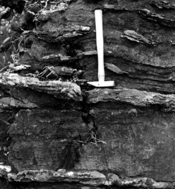 synclines. This is backed up by three pieces of field evidence:
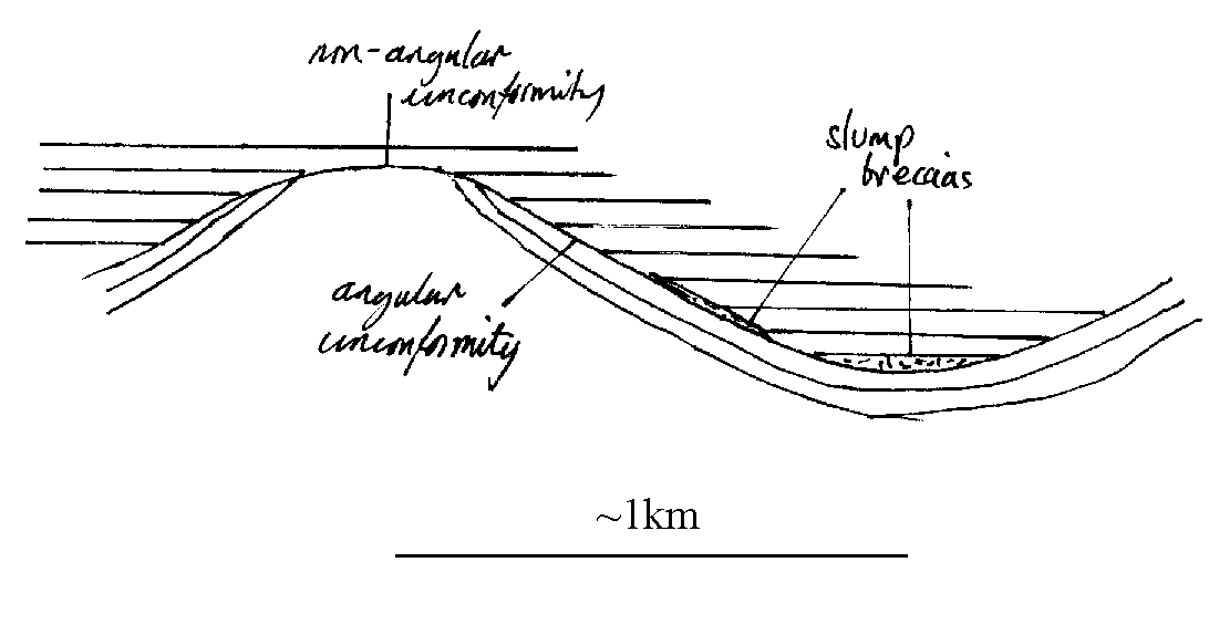
 This evidence suggests that the breccia is not formed in situ on the exposed highs during regional uniform uplift as Button states, but that the highs were eroded out, breccia forming and slumping down slope. In Button's hypothesis, the unconformity would always be bounded by breccia. However, I have described examples of both angular and simple temporal unconformities where no breccia defines the unconformity. I suggest that the lensing of the breccia is caused by minor buckling of the basin caused by the same compression which activated the uplift, viz. movement on the plate boundary to the north. The breccia then accumulated on the slopes and in the troughs of folds, pinching out towards the middles of the fold limbs. (Fig 8.)
 Therefore, I draw the conclusion that the folding in the lower Transvaal Supergroup occurred during the hiati in sedimentation of the Malmani Sub-Group. This is corroborated by the Pretoria sediments to the southwest being unfolded. (Button, 1986; Maresh, 1999, pers. com.) This also disposes of the possibility that the intrusion of the Bushveld could have been the cause of the deformation in question, since it intruded into the middle of the Pretoria Sequence. (Cheney and Twist, 1991) The cause of the folding is episodic reactivation of the Thabazimbi-Murchison Lineament on the boundary of the Zimbabwe craton. The last throes of subduction and the continuing oblique motion occasionally caused in-plane stress fields which could have initiated the folding I am proposing.
Contacts
In general, the contacts were poorly defined throughout the area. This was either because one unit graded into another, or because erosion had acted preferentially at the contact. Some of the most constrained contacts were between the chert rich dolomites and the pure dolomites, although in many places, the problem arose of classifying outcrop with minor chert content.
The most consistently traceable, but not the best constrained contacts were between the shales and neighbouring units. The shale itself rarely appeared in outcrop, but was shattered and strewn over the ground. Nevertheless, these boulders seemed to reflect subcrop well, and constraining the contact within ten metres was frequently possible, especially with Sh3 across the middle of the area.
Relationship with the Bushveld Complex
The predominant dip direction to the south can be attributed to the Bushveld Complex to the south. (Button, 1976) It has long been asserted that subsidence associated with this massive intrusion caused the dip of all surrounding sedimentary units to face towards the intrusion. (Hall, 1932) However, many recent authors have identified the Bushveld synform as a primary feature of the Transvaal Basin, with the Bushveld having only minor effects. I consider this incompatible with the thick sequences of shallow marine sediments which dominate the Transvaal basin.
Most recently, Cheney and Twist (1991) report a previously unknown unconformity along which they propose the Bushveld intruded. They then revert to the Hall explanation of post-intrusive subsidence to explain the present synformal structure surrounding the Bushveld. Alternatively, as Button suggests in 1986, the dip towards the complex could simply be the result of displacement of beds due to the injection of very large quantities of magma.
The Bushveld Complex is the source and cause of mineralisation in the area of study. The intrusion originally overlay the area having intruded along an unconformity in the Pretoria Group in the Upper Transvaal Supergroup. (Cheney and Twist, 1991). The intrusion brought with it heat which drove hydrothermal circulation in the surrounding sediment. This would have carried mineral rich fluids away from the intrusion and into the country rock. There is a trend of mineralisation in my area which can be accounted for by the proximity of the Bushveld Complex to the southwest: it is in this direction that I found the most mineralised rocks.
Therefore, I draw the conclusion that the folding in the lower Transvaal Supergroup occurred during the hiati in sedimentation of the Malmani Sub-Group. This is corroborated by the Pretoria sediments to the southwest being unfolded. (Button, 1986; Maresh, 1999, pers. com.) This also disposes of the possibility that the intrusion of the Bushveld could have been the cause of the deformation in question, since it intruded into the middle of the Pretoria Sequence. (Cheney and Twist, 1991) The cause of the folding is episodic reactivation of the Thabazimbi-Murchison Lineament on the boundary of the Zimbabwe craton. The last throes of subduction and the continuing oblique motion occasionally caused in-plane stress fields which could have initiated the folding I am proposing.
Contacts
In general, the contacts were poorly defined throughout the area. This was either because one unit graded into another, or because erosion had acted preferentially at the contact. Some of the most constrained contacts were between the chert rich dolomites and the pure dolomites, although in many places, the problem arose of classifying outcrop with minor chert content.
The most consistently traceable, but not the best constrained contacts were between the shales and neighbouring units. The shale itself rarely appeared in outcrop, but was shattered and strewn over the ground. Nevertheless, these boulders seemed to reflect subcrop well, and constraining the contact within ten metres was frequently possible, especially with Sh3 across the middle of the area.
Relationship with the Bushveld Complex
The predominant dip direction to the south can be attributed to the Bushveld Complex to the south. (Button, 1976) It has long been asserted that subsidence associated with this massive intrusion caused the dip of all surrounding sedimentary units to face towards the intrusion. (Hall, 1932) However, many recent authors have identified the Bushveld synform as a primary feature of the Transvaal Basin, with the Bushveld having only minor effects. I consider this incompatible with the thick sequences of shallow marine sediments which dominate the Transvaal basin.
Most recently, Cheney and Twist (1991) report a previously unknown unconformity along which they propose the Bushveld intruded. They then revert to the Hall explanation of post-intrusive subsidence to explain the present synformal structure surrounding the Bushveld. Alternatively, as Button suggests in 1986, the dip towards the complex could simply be the result of displacement of beds due to the injection of very large quantities of magma.
The Bushveld Complex is the source and cause of mineralisation in the area of study. The intrusion originally overlay the area having intruded along an unconformity in the Pretoria Group in the Upper Transvaal Supergroup. (Cheney and Twist, 1991). The intrusion brought with it heat which drove hydrothermal circulation in the surrounding sediment. This would have carried mineral rich fluids away from the intrusion and into the country rock. There is a trend of mineralisation in my area which can be accounted for by the proximity of the Bushveld Complex to the southwest: it is in this direction that I found the most mineralised rocks.
History of the Kaapvaal Craton
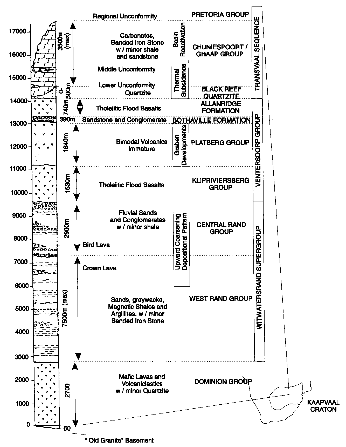
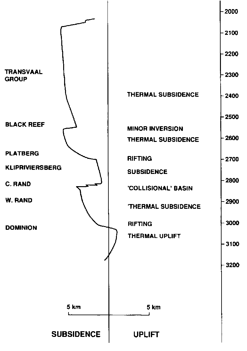
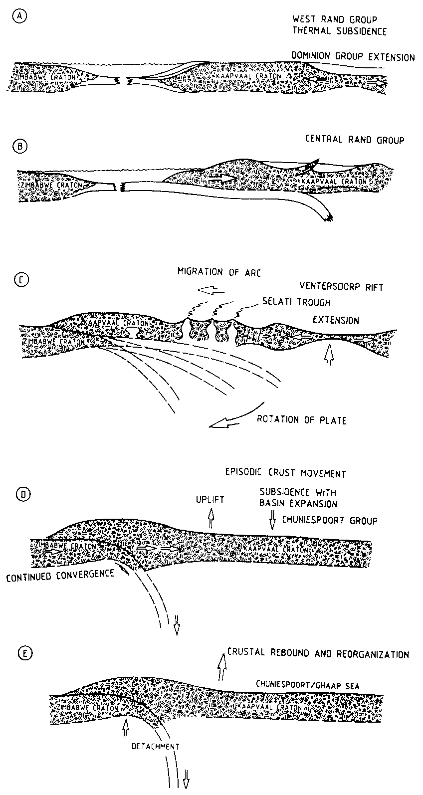
The Kaapvaal Craton is one of a small number of ancient fragments of Archaean continental crust which remain. It is thought to have formed and stabilised between 3.7 and 2.7 Ga ago. It is exceptional in that it is relatively undeformed, although various tectonic events have caused basin formation to occur over the craton yielding a great thickness of sediment. (Button, 1986) 3.7 Ga - 3.0 Ga The generally accepted explanation for the growth of continents is through a combination of subduction related additions and amalgamation of extant lithospheric fragments. There is less of a consensus regarding the growth of continental lithosphere mainly due to a lack of agreement on the rate of continental recycling. The initial appearance of the Kaapvaal shield was from obduction between oceanic plates. "Oceanic" in this context not necessarily having the literal meaning, but indicating that the plates were relatively undifferentiated. The resulting continental nuclei have been compared to the oceanic plateaux in the western Pacific. De Wit (1992) postulates that the formation of continents could only begin once the mid-ocean ridges were submerged by the oceans. Before this time, there was no means of water being included in the crust. The water would reduce the density of the crust by forming minerals such as serpentine, and also water must be added to the crust to facilitate generation of granitic magmas. Only the mid-ocean ridge provides an efficient enough means of incorporating water into crustal rocks to account for the density change required. Another requirement is that the rocks be rich in magnesium, otherwise the water would not be able to form the low density minerals. This was followed by widespread melting and chemical differentiation of the upper lithosphere. With chemical differentiation, some degree of stability was attained, since the plate, now being of lower density, could not be subducted easily. Instead, surrounding oceanic plates would be subducted under it resulting in accumulation of further material by magmatism. (de Wit et al, 1992) The basements consist of calc-alkaline plutonic rocks with volcanics and sediments. These make up the granite-greenstone terrains typical of Archaean cratons. The Kaapvaal craton is exceptional because, of the cratons which stabilised early (before 3Ga), it has been only moderately affected by the deformation which has mangled other cratons of similar age. Only the Pilbara craton of Australia is similarly unravaged. 3.0 Ga - 2.6 Ga Pre-Wolkberg Group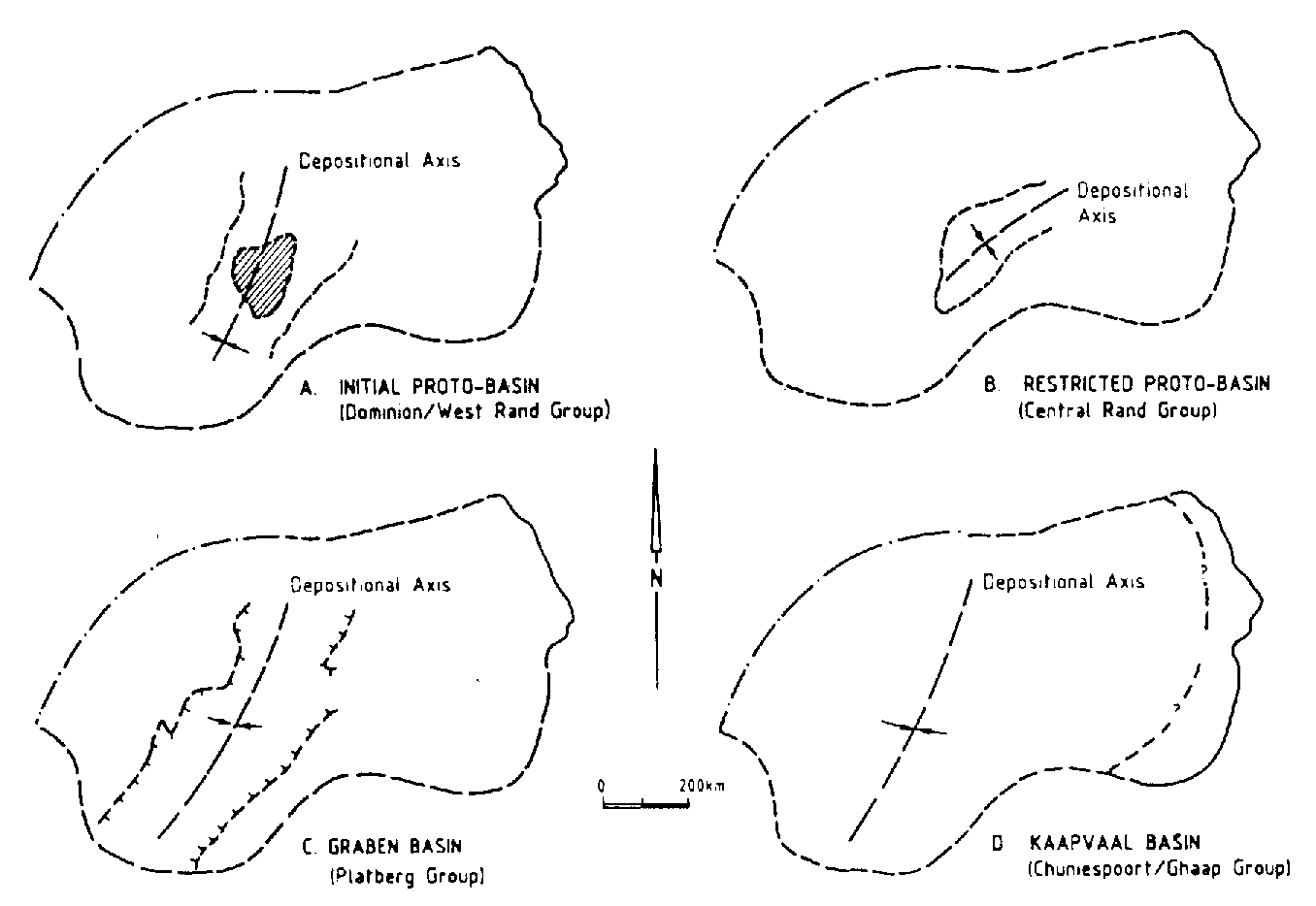 Shortly after the stabilisation of the craton, it underwent a period of extension. This continued on and off for 1 Ga most of the time creating accommodation space into which sediment was deposited: the result being the Witswatersrand basin, filled by the Dominion Group, the Witswatersrand Supergroup, the Ventersdorp Supergroup, the Transvaal Supergroup. The part of this stratigraphic sequence with which we are concerned can be seen in the stratigraphy in the appendix. I was studying a section of the Malmani sub-group of the Chuniespoort Group, of the Transvaal Supergroup.
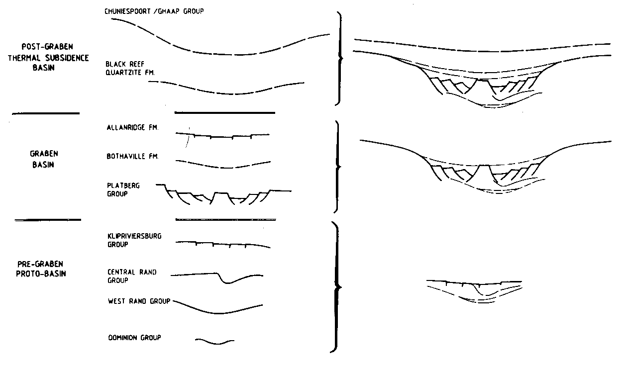
Clendenin et al propose a three-stage rift system to account for the pattern and distribution of the sedimentary basins which cover the basement with more than 17 kilometres of sediment. In addition to the two stages of the standard McKenzie model (1978), Clendenin invokes a third, pre-graben stage, during which a significant proportion of the sediments were deposited before rifting began. (Clendenin 1987,1988) See Fig 10. This is simply a result of stretching causing a necking of the lithosphere which behaves plastically for a time before brittle failure leads to graben development. The cause of the rifting is intimately linked with the Zimbabwe craton to the north. Subsequent successor basins form in areas of existing tectonic weakness, and Fig. 9 shows this happening in the Kaapvaal craton. Refer to Fig. 12 for a cartoon summary. Before the Zimbabwe craton came into play, at about 3.1Ga, rifting occurred due to a thermal anomaly, initially resulting in uplift, rifting, then subsidence in the classic sequence.
The continental cores of the Zimbabwe and Kaapvaal plates collided obliquely at about 2.850 Ga ago. The oblique nature of the collision caused a varying stress field across the plate that allowed the sedimentary basins to be continually reactivated, with short inversions causing regional unconformities. Back arc stretching of the lithosphere from roll-back of the subduction zone contributed to the back arc basin. The orogeny associated with this collision caused flexure of the lithosphere, creating a hinterland basin to the south. A modern parallel for this is the sedimentary basins along the eastern margin of the Andes. (Coward, 1995) The high volcanic arc was a source of silici-clastics and volcanics with which the basins of the Kaapvaal craton were filled.
Shortly after the stabilisation of the craton, it underwent a period of extension. This continued on and off for 1 Ga most of the time creating accommodation space into which sediment was deposited: the result being the Witswatersrand basin, filled by the Dominion Group, the Witswatersrand Supergroup, the Ventersdorp Supergroup, the Transvaal Supergroup. The part of this stratigraphic sequence with which we are concerned can be seen in the stratigraphy in the appendix. I was studying a section of the Malmani sub-group of the Chuniespoort Group, of the Transvaal Supergroup.
Clendenin et al propose a three-stage rift system to account for the pattern and distribution of the sedimentary basins which cover the basement with more than 17 kilometres of sediment. In addition to the two stages of the standard McKenzie model (1978), Clendenin invokes a third, pre-graben stage, during which a significant proportion of the sediments were deposited before rifting began. (Clendenin 1987,1988) See Fig 10. This is simply a result of stretching causing a necking of the lithosphere which behaves plastically for a time before brittle failure leads to graben development. The cause of the rifting is intimately linked with the Zimbabwe craton to the north. Subsequent successor basins form in areas of existing tectonic weakness, and Fig. 9 shows this happening in the Kaapvaal craton. Refer to Fig. 12 for a cartoon summary. Before the Zimbabwe craton came into play, at about 3.1Ga, rifting occurred due to a thermal anomaly, initially resulting in uplift, rifting, then subsidence in the classic sequence.
The continental cores of the Zimbabwe and Kaapvaal plates collided obliquely at about 2.850 Ga ago. The oblique nature of the collision caused a varying stress field across the plate that allowed the sedimentary basins to be continually reactivated, with short inversions causing regional unconformities. Back arc stretching of the lithosphere from roll-back of the subduction zone contributed to the back arc basin. The orogeny associated with this collision caused flexure of the lithosphere, creating a hinterland basin to the south. A modern parallel for this is the sedimentary basins along the eastern margin of the Andes. (Coward, 1995) The high volcanic arc was a source of silici-clastics and volcanics with which the basins of the Kaapvaal craton were filled.
 Wolkberg Group
In the Downs area of the Lekgalameetse Nature Reserve, the Ventersdorp group is represented by the Wolkberg group. This was deposited in the Selati trough, a feature which seems to have arisen from an inherited weakness in the basement granite known as the Thabazimbi-Murchison lineament. The Wolkberg lies unconformably on the adjacent basement. The trough's position can be seen in Fig. 12c adjacent to the back-arc volcanics of subduction zone. It is thought that this zone of weakness took up some oblique strain from the plate convergence nearby. In any case, the Wolkberg group was deposited here contemporaneously with the Platberg Group; the upper part of the Ventersdorp Group. Dating is very unreliable, and since the Wolkberg is unconformity bound, the problem is particularly acute. However, various radiometric age determinations have reached a general consensus on an age of around 2.6 Ga.
Accommodation space was provided by back arc spreading which caused thinning, exploiting the weakness of the lineament. The Wolkberg strata are sub-aerial, with occasional shallow sub-marine, consisting of mostly immature clastics, braided and meandering fluvial deposition, and they thin or wedge out against palaeo-highs. Volcanics in the sequence are characteristically sub-aerial. (Eriksson, 1990)
Wolkberg Group
In the Downs area of the Lekgalameetse Nature Reserve, the Ventersdorp group is represented by the Wolkberg group. This was deposited in the Selati trough, a feature which seems to have arisen from an inherited weakness in the basement granite known as the Thabazimbi-Murchison lineament. The Wolkberg lies unconformably on the adjacent basement. The trough's position can be seen in Fig. 12c adjacent to the back-arc volcanics of subduction zone. It is thought that this zone of weakness took up some oblique strain from the plate convergence nearby. In any case, the Wolkberg group was deposited here contemporaneously with the Platberg Group; the upper part of the Ventersdorp Group. Dating is very unreliable, and since the Wolkberg is unconformity bound, the problem is particularly acute. However, various radiometric age determinations have reached a general consensus on an age of around 2.6 Ga.
Accommodation space was provided by back arc spreading which caused thinning, exploiting the weakness of the lineament. The Wolkberg strata are sub-aerial, with occasional shallow sub-marine, consisting of mostly immature clastics, braided and meandering fluvial deposition, and they thin or wedge out against palaeo-highs. Volcanics in the sequence are characteristically sub-aerial. (Eriksson, 1990)
 After the subduction of the Zimbabwe plate ceased, the Selati depo-centre stopped growing and re-organisation of the thermal structure of the crust led to uplift and erosion to the north, while the southern edge began to grade into the larger craton-wide basin.
 2.6 Ga - 2.1 Ga
Black Reef Quartzite Formation
Once subduction had ended, post-graben thermal subsidence occurred causing an increase in the area of the basin and the first sediment to overlie the crests of the grabens. This is the beginning of the Transvaal Supergroup and happened over the entire Witswatersrand basin, and indeed, the areal extent grew, onlapping occurring at the margins of the basin; but the BRQ does lie conformably on the parts of the Wolkberg in the most rapidly subsiding parts of the basin. This is also where it achieves its maximum thickness of 500m. Elsewhere it is much thinner, often only tens of metres and cuts back through to the basement granite. At its base is a highly auriferous conglomerate which has been extensively exploited, and has yielded more gold than any other source. Higher up, wackes and shales grade into the Malmani dolomites. It is perhaps surprising that a principally fluvial system could cover an entire basin of up to 500,000 square kilometres. This can be accounted for as follows. Firstly, the much greater ratio of sea to land in the early Proterozoic. (Fowler, 1990) This would have meant much greater precipitation and therefore more weathering, and as a consequence a great deal more sediment. The basin was open in the southeast (Eriksson, 1993), and the shallow nature of the basin would not allow the sediment to be transported efficiently, hence accumulating an entire sequence of fluvial deposit over a large proportion of the Witswatersrand Basin.
Chuniespoort Group (Malmani Sub-Group)
(Refer also to the Chapter on Environment of Deposition.)
It turned out, after my injury, that my entire mapping area would be confined to the Malmani Dolomites, the lowest subgroup of the Chuniespoort Group, which also contains the Penge formation of Banded Iron-stone and the Duitschland Formation, primarily of dolomite. Although the formation is richly stromatolitic, very few examples of microfossils have been found.
Today the Transvaal sequence, including the Malmani Dolomites, is preserved in two structural sub-basins, one in the northeastern Transvaal, the other in the Northern Cape Province. The significant duration of formation of this sequence and the almost exclusively shallow marine deposits tell a tale of an extremely stable tectonic environment. This was only interrupted by occasional minor inversions. Evidence I found relating to tectonism in Malmani time is discussed in detail in the "Interpretation of the Shale Breccia" in the Structure Chapter.
A stratigraphy of the Malmani has been attempted in a different part of the Transvaal basin. Unfortunately, there is poor correlation with my stratigraphy, and no meaningful links could be drawn.
The end of the Chuniespoort group comes with a major inversion preceding the Pretoria Sequence. The duration of this unconformity is poorly constrained, and could have lasted up to 300Ma. The cause of it has been linked to the break off of the remainder of the subducted Zimbabwe slab which had been gradually sinking. (Fig. 12) The removal of the downward force led to craton-wide uplift, and the unconformity.
2.0Ga to Present
The huge Bushveld intrusion of mafics and ultramafics is well constrained at 2095Ga ago. It intruded into the Pretoria Sequence at the top of the Transvaal Supergroup, and there originally overlay the sediments under study. As has been explained, it was a source of mineralising fluids which the heat from the intrusion drove around the country rock. It has left us a legacy of extensive deposits of numerous ores, but in particular chromium, vanadium, andalusite and asbestos.
Seismic studies and velocity inversions interestingly show a velocity structure somewhat greater than the global average down to a depth of 350km. The craton is also characterised by low heat flow and diamond-bearing kimberlites. The adjacent mobile belts have a higher heat flow and their kimberlites do not contain diamonds. This implies that the cratons have a lithospheric thickness of at least 120km, unlike the neighbouring belts. (Jones, 1988)
2.6 Ga - 2.1 Ga
Black Reef Quartzite Formation
Once subduction had ended, post-graben thermal subsidence occurred causing an increase in the area of the basin and the first sediment to overlie the crests of the grabens. This is the beginning of the Transvaal Supergroup and happened over the entire Witswatersrand basin, and indeed, the areal extent grew, onlapping occurring at the margins of the basin; but the BRQ does lie conformably on the parts of the Wolkberg in the most rapidly subsiding parts of the basin. This is also where it achieves its maximum thickness of 500m. Elsewhere it is much thinner, often only tens of metres and cuts back through to the basement granite. At its base is a highly auriferous conglomerate which has been extensively exploited, and has yielded more gold than any other source. Higher up, wackes and shales grade into the Malmani dolomites. It is perhaps surprising that a principally fluvial system could cover an entire basin of up to 500,000 square kilometres. This can be accounted for as follows. Firstly, the much greater ratio of sea to land in the early Proterozoic. (Fowler, 1990) This would have meant much greater precipitation and therefore more weathering, and as a consequence a great deal more sediment. The basin was open in the southeast (Eriksson, 1993), and the shallow nature of the basin would not allow the sediment to be transported efficiently, hence accumulating an entire sequence of fluvial deposit over a large proportion of the Witswatersrand Basin.
Chuniespoort Group (Malmani Sub-Group)
(Refer also to the Chapter on Environment of Deposition.)
It turned out, after my injury, that my entire mapping area would be confined to the Malmani Dolomites, the lowest subgroup of the Chuniespoort Group, which also contains the Penge formation of Banded Iron-stone and the Duitschland Formation, primarily of dolomite. Although the formation is richly stromatolitic, very few examples of microfossils have been found.
Today the Transvaal sequence, including the Malmani Dolomites, is preserved in two structural sub-basins, one in the northeastern Transvaal, the other in the Northern Cape Province. The significant duration of formation of this sequence and the almost exclusively shallow marine deposits tell a tale of an extremely stable tectonic environment. This was only interrupted by occasional minor inversions. Evidence I found relating to tectonism in Malmani time is discussed in detail in the "Interpretation of the Shale Breccia" in the Structure Chapter.
A stratigraphy of the Malmani has been attempted in a different part of the Transvaal basin. Unfortunately, there is poor correlation with my stratigraphy, and no meaningful links could be drawn.
The end of the Chuniespoort group comes with a major inversion preceding the Pretoria Sequence. The duration of this unconformity is poorly constrained, and could have lasted up to 300Ma. The cause of it has been linked to the break off of the remainder of the subducted Zimbabwe slab which had been gradually sinking. (Fig. 12) The removal of the downward force led to craton-wide uplift, and the unconformity.
2.0Ga to Present
The huge Bushveld intrusion of mafics and ultramafics is well constrained at 2095Ga ago. It intruded into the Pretoria Sequence at the top of the Transvaal Supergroup, and there originally overlay the sediments under study. As has been explained, it was a source of mineralising fluids which the heat from the intrusion drove around the country rock. It has left us a legacy of extensive deposits of numerous ores, but in particular chromium, vanadium, andalusite and asbestos.
Seismic studies and velocity inversions interestingly show a velocity structure somewhat greater than the global average down to a depth of 350km. The craton is also characterised by low heat flow and diamond-bearing kimberlites. The adjacent mobile belts have a higher heat flow and their kimberlites do not contain diamonds. This implies that the cratons have a lithospheric thickness of at least 120km, unlike the neighbouring belts. (Jones, 1988)
Environment of Deposition
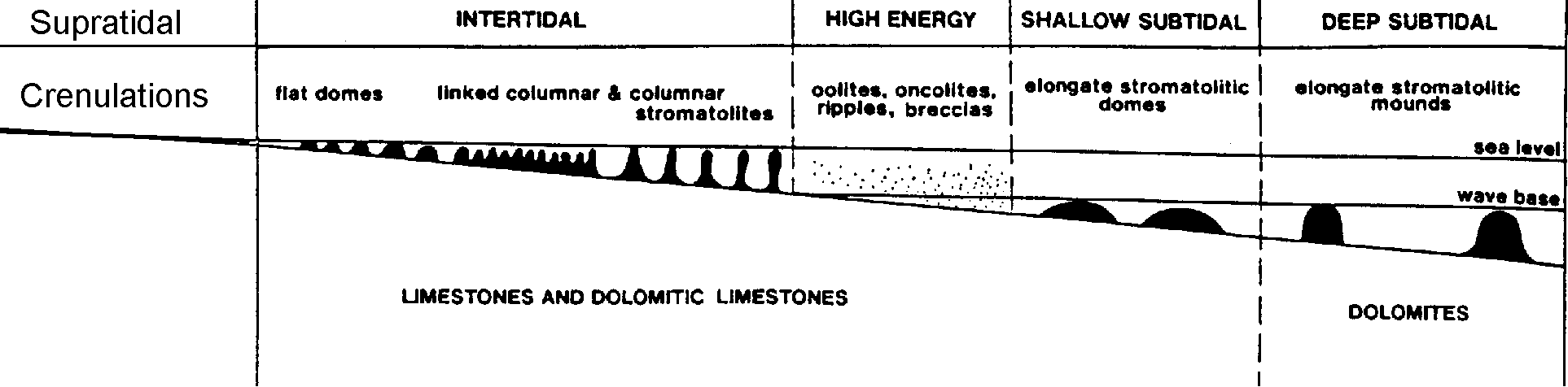
Water Depth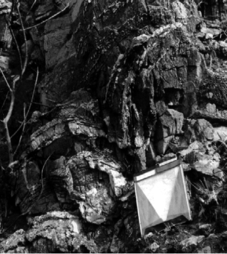 The basin underwent subsidence resulting in the formation of an epeiric sea covering over 500,000 square kilometres and most of the Kaapvaal craton.. Button interprets the range of stromatolites and sedimentary structures as simply due to a very wide, flat gently sloping marine platform, with a low hinterland. This low hinterland was to the north being the remaining uplands from the collision between the Zimbabwe and Kaapvaal cratons and produced very little clastic sediment throughout the Malmani sequence, (5% of the sediment, mostly in the basal Oaktree formation which grades down into the Black Reef Quartzite). This corresponds with the few scraps of palaeocurrent data which I gleaned. At localities "aq", "ar", "as" and "az" at which I recorded ripples with an approximate east - west trend. My fold axes follow the same trend, so deformation can be ignored. The result is a north - south oriented palaeocurrent, which is expected to be seen.
Eriksson et al (1992) offer a spectrum of peri-tidal environments on a ramp to account for the variety of stromatolites found over the entire basin. In my modestly sized area, only two scales of stromatolite were found: a small-scale, crenulated style and metre scale rounded, linked domes (Fig. 15). I suspect a supratidal, and/or lagoon region is responsible for the crenulated organo-sediments. I was unable to confirm this by discovering any desiccation features, or evaporite minerals. These flat sub-centimetre stromatolites do not otherwise fit in Eriksson's model which only reaches from deep subtidal to intertidal. I did not find any evidence of stromatolites bigger than metre scale. (As in Fig. 14) This could be either because a) they were not there, or b) I was unable to identify them as such in the field. I think that the sequence of dolomite which I mapped was mostly supratidal to intertidal with some high energy regions.
The basin underwent subsidence resulting in the formation of an epeiric sea covering over 500,000 square kilometres and most of the Kaapvaal craton.. Button interprets the range of stromatolites and sedimentary structures as simply due to a very wide, flat gently sloping marine platform, with a low hinterland. This low hinterland was to the north being the remaining uplands from the collision between the Zimbabwe and Kaapvaal cratons and produced very little clastic sediment throughout the Malmani sequence, (5% of the sediment, mostly in the basal Oaktree formation which grades down into the Black Reef Quartzite). This corresponds with the few scraps of palaeocurrent data which I gleaned. At localities "aq", "ar", "as" and "az" at which I recorded ripples with an approximate east - west trend. My fold axes follow the same trend, so deformation can be ignored. The result is a north - south oriented palaeocurrent, which is expected to be seen.
Eriksson et al (1992) offer a spectrum of peri-tidal environments on a ramp to account for the variety of stromatolites found over the entire basin. In my modestly sized area, only two scales of stromatolite were found: a small-scale, crenulated style and metre scale rounded, linked domes (Fig. 15). I suspect a supratidal, and/or lagoon region is responsible for the crenulated organo-sediments. I was unable to confirm this by discovering any desiccation features, or evaporite minerals. These flat sub-centimetre stromatolites do not otherwise fit in Eriksson's model which only reaches from deep subtidal to intertidal. I did not find any evidence of stromatolites bigger than metre scale. (As in Fig. 14) This could be either because a) they were not there, or b) I was unable to identify them as such in the field. I think that the sequence of dolomite which I mapped was mostly supratidal to intertidal with some high energy regions.
 Dolomite: primary or secondary?
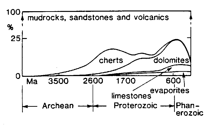 Age alone is not a solution to the problem of the great volume of ancient dolomites with respect to limestones, see Fig 16. Main explanations are primary precipitation from seawater, or conditions more conducive to dolomitisation. The particular problem with Precambrian dolomites is that their textures are often very well preserved, indicating that replacement with dolomite must have occurred very soon after sedimentation, or that dolomite was precipitated directly. The problem with direct precipitation of dolomite, is that although it is thermodynamically favourable, even in today's oceans, there are significant kinetic barriers to be overcome. SO42+ is known to have an inhibiting effect on dolomitisation. A high PCO2 and a higher temperature would also have increased the favourability of dolomite precipitation. What I see as the most interesting solution is the mediation of the precipitation of dolomite, or at least very rapid dolomitisation by organic acids. It seems too much of a coincidence that such a prodigious accumulation of stromatolites appear with vast quantities of dolomite in the Proterozoic. However, while dolomitisation in recent times is so poorly understood, it seems unlikely that the problem of Precambrian dolomites will be addressed satisfactorily in the near future.
Banded Iron Formation
These were laid down in a deep-water environment, mainly owing to their extraordinary lateral continuity. Beds of centimetre thickness can in some cases be traced for kilometres. It is also thought that low sulphate content of the ocean stopped siderite from forming.
Lithology descriptions
The principal lithology was dolomite that was occasionally augmented by thin beds of shale. Fortunately, there was considerable interest and variety within the dolomite. Firstly the dolomite was complicated by stromatolites, which were marked out by silica rich layers.
Although injury prevented me reaching it, I will also describe the Banded Iron Stone since it is important in the regional geology, not to mention interesting in it's own right. I have seen numerous hand specimens from a colleague on an abutting area (Maresh, 1999), and it is these which I am using as a basis for my description.
Dolomite Overview
The varying properties of the dolomite between bedding planes strongly suggests that channeling of mineralising fluid flow is responsible. The whole sequence is richly stromatolitic (apart from in the shale and shale breccia beds), and exhibits biological accretion on a number of scales. These were only seen in the silicified dolomite, since preservation of any features in the purer dolomite was poor. These varied from crinkled laminations, one or two millimetres high, to centimetre scale bulges to mounds of metre scale; Fig.14. The organisms responsible for the accumulation of layers have been reclassified from blue-green algae to cyano-bacteria. In this report, I refer to them as algae for brevity.
Cherty dolomite. (Cd1, Cd2)
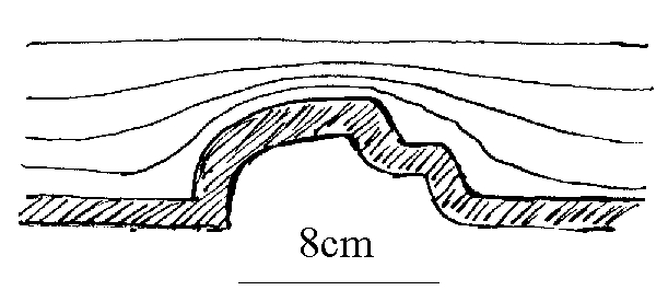
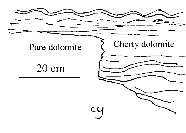
The silica is not homogeneously distributed throughout these units. These were typically in strata 1cm to 5cm thick, and separated by 10cm-30cm of pure dolomite. The inbetween layers did not fizz with acid, indicating their dolomitic nature. It was difficult to assess the lateral continuity of these layers, but I estimate that it varied from metres to hundreds of metres. There was evidence of truncation of these layers. I interpret these as a reactivation surfaces. This could be an expression of one of the erosional unconformities within the Chuniespoort group; perhaps the Eccles/Frisco unconformity. See Figs. 6 and 7 for two examples of unconformities in the area. Stromatolites of scales between sub centimtre and up to a metre were common, and the chert bands which weathered proud showed them clearly. (Fig. 14) Cd1 has a stratigraphic thickness of 100m; Cd2 of 150m. In the field I classified four types of silica rich layer within the cherty dolomite, although I was unable to map in this amount of detail. This categorisation is both morphological and compositional. These subdivisions turned out not to be mappable, so I will omit their details.
Dolomite with shale breccia lenses. Chert poor. (Ds1, Ds2, Ds3)
This unit was mostly buff coloured. Very little structure was preserved in the silica free beds, and it was seldom possible to take dip and strike measurements from this lithology. Occasionally, remnants of what appear to be algal mats may be picked out. These are not reflected in thin section. There is a relatively sharp boundary with siliceous dolomite units.
The Ds1 unit was not observed to have any shale breccia in it, but is grouped with Ds2 and Ds3 due to the similarity of the rest of the unit. Ds1 had a stratigraphic thickness of 90m, Ds2 of 190m, while Ds3 did not have an upper constraint.
Age alone is not a solution to the problem of the great volume of ancient dolomites with respect to limestones, see Fig 16. Main explanations are primary precipitation from seawater, or conditions more conducive to dolomitisation. The particular problem with Precambrian dolomites is that their textures are often very well preserved, indicating that replacement with dolomite must have occurred very soon after sedimentation, or that dolomite was precipitated directly. The problem with direct precipitation of dolomite, is that although it is thermodynamically favourable, even in today's oceans, there are significant kinetic barriers to be overcome. SO42+ is known to have an inhibiting effect on dolomitisation. A high PCO2 and a higher temperature would also have increased the favourability of dolomite precipitation. What I see as the most interesting solution is the mediation of the precipitation of dolomite, or at least very rapid dolomitisation by organic acids. It seems too much of a coincidence that such a prodigious accumulation of stromatolites appear with vast quantities of dolomite in the Proterozoic. However, while dolomitisation in recent times is so poorly understood, it seems unlikely that the problem of Precambrian dolomites will be addressed satisfactorily in the near future.
Banded Iron Formation
These were laid down in a deep-water environment, mainly owing to their extraordinary lateral continuity. Beds of centimetre thickness can in some cases be traced for kilometres. It is also thought that low sulphate content of the ocean stopped siderite from forming.
Lithology descriptions
The principal lithology was dolomite that was occasionally augmented by thin beds of shale. Fortunately, there was considerable interest and variety within the dolomite. Firstly the dolomite was complicated by stromatolites, which were marked out by silica rich layers.
Although injury prevented me reaching it, I will also describe the Banded Iron Stone since it is important in the regional geology, not to mention interesting in it's own right. I have seen numerous hand specimens from a colleague on an abutting area (Maresh, 1999), and it is these which I am using as a basis for my description.
Dolomite Overview
The varying properties of the dolomite between bedding planes strongly suggests that channeling of mineralising fluid flow is responsible. The whole sequence is richly stromatolitic (apart from in the shale and shale breccia beds), and exhibits biological accretion on a number of scales. These were only seen in the silicified dolomite, since preservation of any features in the purer dolomite was poor. These varied from crinkled laminations, one or two millimetres high, to centimetre scale bulges to mounds of metre scale; Fig.14. The organisms responsible for the accumulation of layers have been reclassified from blue-green algae to cyano-bacteria. In this report, I refer to them as algae for brevity.
Cherty dolomite. (Cd1, Cd2)
The silica is not homogeneously distributed throughout these units. These were typically in strata 1cm to 5cm thick, and separated by 10cm-30cm of pure dolomite. The inbetween layers did not fizz with acid, indicating their dolomitic nature. It was difficult to assess the lateral continuity of these layers, but I estimate that it varied from metres to hundreds of metres. There was evidence of truncation of these layers. I interpret these as a reactivation surfaces. This could be an expression of one of the erosional unconformities within the Chuniespoort group; perhaps the Eccles/Frisco unconformity. See Figs. 6 and 7 for two examples of unconformities in the area. Stromatolites of scales between sub centimtre and up to a metre were common, and the chert bands which weathered proud showed them clearly. (Fig. 14) Cd1 has a stratigraphic thickness of 100m; Cd2 of 150m. In the field I classified four types of silica rich layer within the cherty dolomite, although I was unable to map in this amount of detail. This categorisation is both morphological and compositional. These subdivisions turned out not to be mappable, so I will omit their details.
Dolomite with shale breccia lenses. Chert poor. (Ds1, Ds2, Ds3)
This unit was mostly buff coloured. Very little structure was preserved in the silica free beds, and it was seldom possible to take dip and strike measurements from this lithology. Occasionally, remnants of what appear to be algal mats may be picked out. These are not reflected in thin section. There is a relatively sharp boundary with siliceous dolomite units.
The Ds1 unit was not observed to have any shale breccia in it, but is grouped with Ds2 and Ds3 due to the similarity of the rest of the unit. Ds1 had a stratigraphic thickness of 90m, Ds2 of 190m, while Ds3 did not have an upper constraint.
 There was a small amount of fizzing when 10% HCl solution was introduced to a fresh surface. Weathered surfaces fizzed a little more. With pure dolomite, we expect no fizzing, so any significant reaction with acid indicates some dedolomitisation.
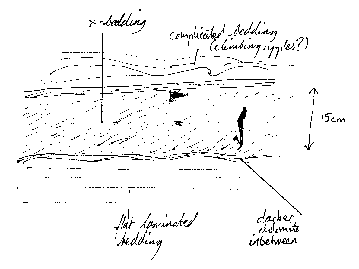
Some parts had colour banding, with darker, chocolate coloured and lighter, buff coloured bands following bedding. The buff bands fizzed weakly in acid, the dark bands did not. I account for this by dedolomitisation occurring. The iron rich buff coloured layers dedolomitise more easily due to the oxidation of Fe2+ (which is substituting for Mg2+) to Fe3+, thus breaking down the dolomite structure, releasing CaCO3. The darker bands are poorer in iron, showing none of the buff colouration due to the ferric ion, and so are not prone to this process. Very rarely, near surface sedimentary structures were preserved. For example, cross bedding in the buff dolomite ("gq" 8358 7421), Fig. 17.
Mineralisation occurred exclusively in the darker layers. Mineralisation was considerably greater in the south of my area than the north where it was mostly absent. Please refer to the section discussing the influence of the Bushveld complex in the Structure chapter.
The actual minerals occurred in three habits: octahedrons, square cross section prisms, and platy crystals. The square prisms were of a soft dark grey mineral. A senior member of the Department of Earth Sciences, Cambridge University suggested these might be scapolite, (Chinnor, pers. com.) The platy mineral was soft with a metallic sheen, and is probably galena, PbS. The reddish octahedral mineral was found rarely but was positively identified as a manganese oxide by Ron Uken (1998, pers. com.)
Shale breccia (part of Ds units)
There was a small amount of fizzing when 10% HCl solution was introduced to a fresh surface. Weathered surfaces fizzed a little more. With pure dolomite, we expect no fizzing, so any significant reaction with acid indicates some dedolomitisation.
Some parts had colour banding, with darker, chocolate coloured and lighter, buff coloured bands following bedding. The buff bands fizzed weakly in acid, the dark bands did not. I account for this by dedolomitisation occurring. The iron rich buff coloured layers dedolomitise more easily due to the oxidation of Fe2+ (which is substituting for Mg2+) to Fe3+, thus breaking down the dolomite structure, releasing CaCO3. The darker bands are poorer in iron, showing none of the buff colouration due to the ferric ion, and so are not prone to this process. Very rarely, near surface sedimentary structures were preserved. For example, cross bedding in the buff dolomite ("gq" 8358 7421), Fig. 17.
Mineralisation occurred exclusively in the darker layers. Mineralisation was considerably greater in the south of my area than the north where it was mostly absent. Please refer to the section discussing the influence of the Bushveld complex in the Structure chapter.
The actual minerals occurred in three habits: octahedrons, square cross section prisms, and platy crystals. The square prisms were of a soft dark grey mineral. A senior member of the Department of Earth Sciences, Cambridge University suggested these might be scapolite, (Chinnor, pers. com.) The platy mineral was soft with a metallic sheen, and is probably galena, PbS. The reddish octahedral mineral was found rarely but was positively identified as a manganese oxide by Ron Uken (1998, pers. com.)
Shale breccia (part of Ds units)
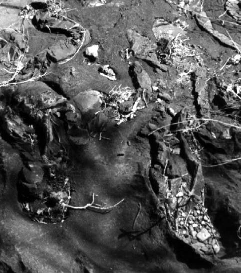 Some lenses within the chert free dolomite contained contorted shards and shreds of shale. These are tectonic in origin, although at first I mistook them for rip-up clasts. The shale fragments occur exclusively in the buff layers within the colour banded pure dolomite. The shale occupies between 0 and 90 percent of the buff bands. I could not find any evidence of flow; for example, there was no clast imbrication. The lenses reached a maximum stratigraphic thickness of about 30m.
The size of the shale fragments varies from sub-millimetre to tens of centimetres. The modal clast size was ~10mm. The larger chunks were often found apart from other fragments. At grid ref. "jf" (8348 7523), a shale bed tens of metres long was exposed. It was highly deformed, and torn up; Fig 18. Perhaps this was left at an earlier stage of deformation than the smaller fragments seen elsewhere.
Carbonaceous Shale (Sh1, Sh2, Sh3)
These units probably occurred in conformable beds, although the actual contact was never seen. It was impossible to find any secondary cleavage in most of the outcropping shale, although some measurements were made; q.v. locality "eo" at (8285 7195). The approximate east-west strike of the cleavage is consistent with the regional deformation as shown by the folding.
Sh1 was not constrained to the north, but is expected to be between 10m and 25m stratigraphic thickness as are the other two shale units. Some examples showed mineralisation, which in a few cases had returned to solution leaving a rock pitted with square cross-sectioned pores, pseudomorphing after the disappeared mineral.
In thin-section, not much could be seen apart from uniform mica alignment parallel to the plane of compression, and in the case of this particular section, also parallel to bedding. The sections were darkened by an opaque dusting, presumed to be graphite in accordance with Eriksson and Clendenin. (1990). Very occasional clasts of quartz appeared, but were insignificant.
Some lenses within the chert free dolomite contained contorted shards and shreds of shale. These are tectonic in origin, although at first I mistook them for rip-up clasts. The shale fragments occur exclusively in the buff layers within the colour banded pure dolomite. The shale occupies between 0 and 90 percent of the buff bands. I could not find any evidence of flow; for example, there was no clast imbrication. The lenses reached a maximum stratigraphic thickness of about 30m.
The size of the shale fragments varies from sub-millimetre to tens of centimetres. The modal clast size was ~10mm. The larger chunks were often found apart from other fragments. At grid ref. "jf" (8348 7523), a shale bed tens of metres long was exposed. It was highly deformed, and torn up; Fig 18. Perhaps this was left at an earlier stage of deformation than the smaller fragments seen elsewhere.
Carbonaceous Shale (Sh1, Sh2, Sh3)
These units probably occurred in conformable beds, although the actual contact was never seen. It was impossible to find any secondary cleavage in most of the outcropping shale, although some measurements were made; q.v. locality "eo" at (8285 7195). The approximate east-west strike of the cleavage is consistent with the regional deformation as shown by the folding.
Sh1 was not constrained to the north, but is expected to be between 10m and 25m stratigraphic thickness as are the other two shale units. Some examples showed mineralisation, which in a few cases had returned to solution leaving a rock pitted with square cross-sectioned pores, pseudomorphing after the disappeared mineral.
In thin-section, not much could be seen apart from uniform mica alignment parallel to the plane of compression, and in the case of this particular section, also parallel to bedding. The sections were darkened by an opaque dusting, presumed to be graphite in accordance with Eriksson and Clendenin. (1990). Very occasional clasts of quartz appeared, but were insignificant.
 Banded Ironstone
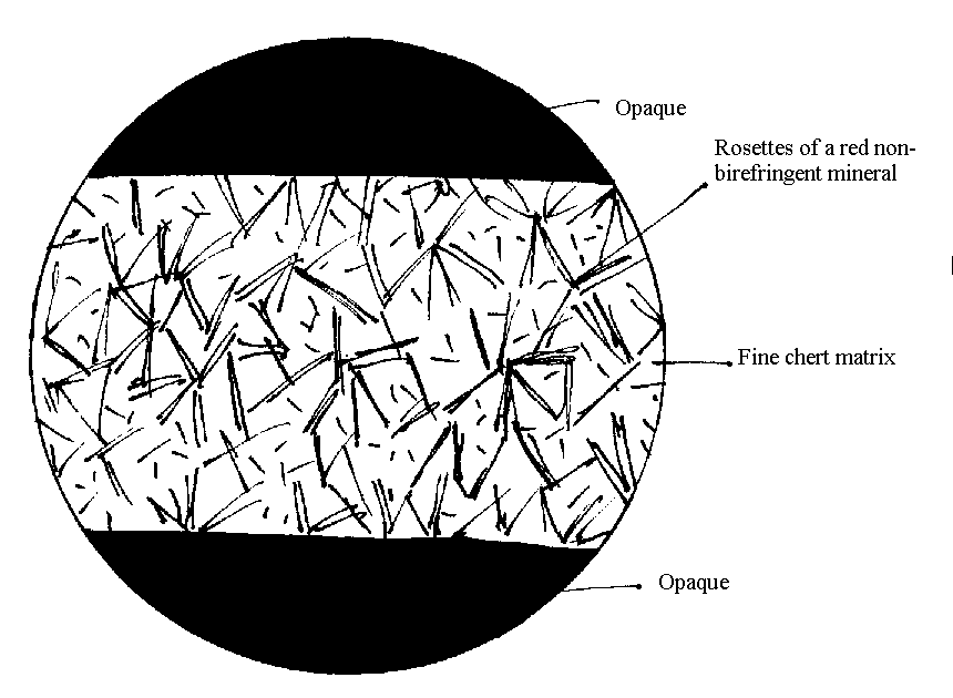
This is a dense red rock with prominent bands of between millimetre and centimetre size. The bands alternate between metallic grey and rust red. A thin section (4mm diameter field of view) showed that the rusty layers had a matrix of fine chert overprinted by bunches of elongate opaque iron minerals with common centres. The metallic grey layers are opaque in thin section, but were known to be magnetite. One sample exhibited magnetite pseudomorphing asbestos, indicating an age relationship, since primary magnetite doesn't grow in an asbestiform habit.
The Banded Iron Formation has a very high concentration of iron, in various forms. It is noted for phenomenal lateral continuity of its layers. From this, we infer a very stable tectonic regime which allowed protracted deep-water sedimentation of these extremely iron rich sediments. Asbestiform mineralisation is common, and is mostly riebeckite (blue asbestos) and grunerite in the amphibole solid solution. This was once mined extensively, but the blue asbestos mines are no longer active owing to the carcinogenic properties.
Banded Ironstone
This is a dense red rock with prominent bands of between millimetre and centimetre size. The bands alternate between metallic grey and rust red. A thin section (4mm diameter field of view) showed that the rusty layers had a matrix of fine chert overprinted by bunches of elongate opaque iron minerals with common centres. The metallic grey layers are opaque in thin section, but were known to be magnetite. One sample exhibited magnetite pseudomorphing asbestos, indicating an age relationship, since primary magnetite doesn't grow in an asbestiform habit.
The Banded Iron Formation has a very high concentration of iron, in various forms. It is noted for phenomenal lateral continuity of its layers. From this, we infer a very stable tectonic regime which allowed protracted deep-water sedimentation of these extremely iron rich sediments. Asbestiform mineralisation is common, and is mostly riebeckite (blue asbestos) and grunerite in the amphibole solid solution. This was once mined extensively, but the blue asbestos mines are no longer active owing to the carcinogenic properties.
Conclusion and Synthesis
The deposition on the Kaapvaal craton has a long history, during which a combination of weakened basement and a fluctuating tectonic regime have induced formation of very deep sedimentary basins. The tectonic influence has come mainly from the oblique subduction of the Zimbabwe craton, and the subsequent collisions of the two continental shields. There is a characteristic distribution and style of sedimentation in response to these tectonic stimuli. Late reorganisation between the adjacent plates along the Thambazimbi-Murchison lineament resulted in minor basin inversions during the deposition of the Malmani Dolomites. The result in my map area is an approximately 2 kilometre wavelength parasitised fold plunging gently to the west. I have shown with evidence from the field (from the shale breccia lenses) that there was not simply uplift, but at least one phase of deformation associated with the minor basin inversions. Mineralisation gives away the formerly closer proximity to the Bushveld Complex. The last stage of the episode of interaction between the two cratons is marked by the breaking away of the subducted remnants of the Zimbabwe plate. This caused the sealing of the end of the Chuniespoort Group with a substantial period of uplift and erosion, forming an unconformity with the overlying Pretoria Sequence. The undeformed bedding of the Pretoria Group is further evidence that the folds I was mapping were made during Malmani time, although probably not syn-depositionally.
Bibliography
BUTTON A., 1973. The stratigraphic history of the Malmani in the East and North-East Transvaal. Transactions of the Geological Society of South Africa, 77, 229-248 BUTTON, A., 1976. Stratigraphy and relations of the Bushveld floor in the Eastern Transvaal. Transactions of the Geological Society of South Africa, 79, 3-12 BUTTON, A., 1986. The.Transvaal sub-basin of the Transvaal Sequence. Mineral Deposits of Southern Africa, 1986, 811-817. CHENEY S.E. and TWIST D.,1991. The conformable emplacement of the Bushveld mafic rocks along a regional unconformity in the Transvaal succession of South Africa. Precambrian Research, 52, 115-132. CLENDENIN C. W. et al, 1987. An early Proterozoic three-stage rift system, Kaapvaal Craton, South Africa. Tectonophysics, 145, 73-86 CLENDENIN C. W. et al, 1988. Tectonic style and mechanism of early Proterozoic successor basin development, southern Africa. Tectonophysics, 156, 275-291 COWARD, M. P., 1995. Early Precambrian Processes, Geological Society Special Publication, 95, 243-269. ERIKSSON, P. G., et al, 1993. The Transvaal Sequence: an overview. Journal of African Earth Sciences, 16, no. 1,2 pp25-51, 1993. ERIKSSON, P. G., CLENDENIN C.W., 1990. A review of the Transvaal Sequence, South Africa. Journal of African Earth Sciences, 10, No 1,2, 101-116. FOWLER, M., 1990. The Solid Earth. JONES, M. J.,1988. Geophysical Resources, 93, 3234-3260 (1988) LOGAN, B. W., 1961. Cryptozooan and associated stromatolites from the Recent, Shark Bay, Western Australia. Journal of Geology, 69, 517-533. McKENZIE, D., 1978. Some remarks on the development of sedimentary basins. Earth Planet Sci. Lett., 40, 25-32 De WIT, M.J, 1992. Formation of an Archaean Continent. Nature, 357
Appendix